The Manifestation of Salt Dome Tectonics in the Shallow Northern Part of the Caspian Sea
1Institute of Water Problems of the Russian Academy of Sciences, Astrakhan, Russia
2Astrakhan State University named after V.N. Tatishchev, Russia
Author and article information
Cite this as
Bukharitsin PI, et al. The Manifestation of Salt Dome Tectonics in the Shallow Northern Part of the Caspian Sea. Ann Mar Sci. 2026; 10(1): 24-27. Available from: 10.17352/ams.000053
Copyright License
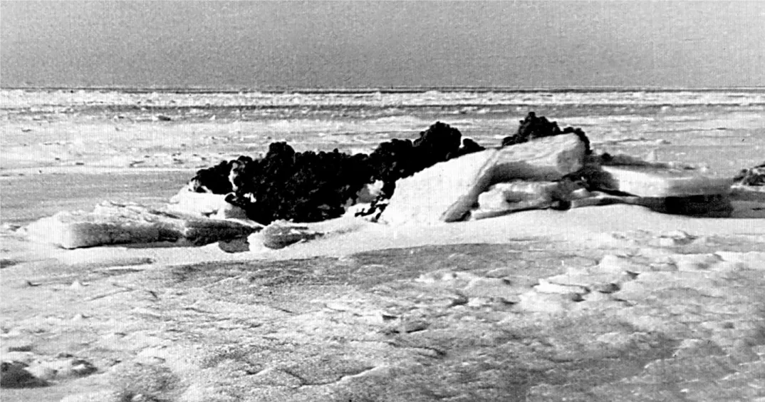
© 2026 Bukharitsin PI, et al. This is an open-access article distributed under the terms of the Creative Commons Attribution License, which permits unrestricted use, distribution, and reproduction in any medium, provided the original author and source are credited.In the autumn of 2025, near the island of Chistaya Banka (the Russian sector of the Northern Caspian Sea, coordinates: N: 45.20396; E: 048.13528), Astrakhan fishermen came across a strange sandbar, which consisted not of the usual mixture of sand, silt, and broken mollusk shells, but of crushed stone, as it turned out later, marl. They marked the coordinates of the location, took photos and videos of their discovery, and submitted a sample of the stone to the Astrakhan Regional Branch of the Russian Geographical Society. The first inspection of the sample confirmed the initial assumption that it was marl (a sedimentary rock that is intermediate between clay and limestone. Marl has been formed over millions of years from the particles of clay, limestone, sand, and mineral carbonate residues. However, this rock is not durable and can be easily transformed by geological, climatic, and erosive processes. The unexpected discovery aroused interest, as none of the previously published sources (scientific articles, maps, and diagrams of the bottom sediments in the shallow northern part of the Caspian Sea) mentioned the occurrence of sedimentary rocks at the surface. The bottom of the central parts of the area is subject to wave action, which is the main relief-forming factor here, and is mainly responsible for the distribution of sedimentary material over the bottom. Sea ice can also have a direct mechanical, thermal, and physical-chemical effect on the bottom and coast. Among these effects, the most dangerous is exaration, which is the destructive mechanical effect of ice on the ground, caused by the dynamics of the ice cover, ice crevasses, and ice floes, which are influenced by hydrometeorological factors and the topography of the coastal zone. The presence of salt domes in the Northern Caspian Sea has an impact not only on ice formation processes. It also manifests itself in the hydrological and hydrobiological characteristics of the waters in these areas of the sea, which is of both scientific and practical interest. Unfortunately, these areas of the sea are difficult to access for expeditionary research, both from the sea and from the shore, so it is too early to draw definitive conclusions.
The unexpected discovery aroused interest, as none of the previously published printed sources (scientific articles, maps, and diagrams of the bottom sediments in the shallow northern part of the Caspian Sea) mention the exposure of sedimentary rock formations at the surface (Figure 1) [1–3].
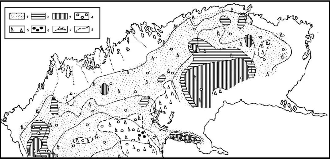
1 ― powdery sand; 2 ― silty sand; 3 ― sandy silt; 4 ― whole shell; 5 ― broken shell; 6 ― oolitic sand; 7 ― algae; 8 ― boundaries of the distribution areas of bottom sediments
The purpose of this publication is to draw scientists’ attention to the modern processes of salt‑dome tectogenesis in the water area of the Northern Caspian Sea, since, up to the present time, nothing is known about the exposure of bedrock in the shallow northern part of the Caspian Sea. For further research, a sample of this rock was taken. On the surface of the selected sample, there is a thin, uneven, loose film of light-yellow carbonates (Figures 2,3). Usually, the marl is not strong but chalk‑like and loose. However, with increasing depth, at the stage of early catagenesis, or protogenesis, it becomes denser, the carbonates in it recrystallize, and the marl becomes hard. The studied sample is stone‑like and dense. It was brought to the surface as a result of salt‑dome tectogenesis processes, and its age is quite difficult to determine.
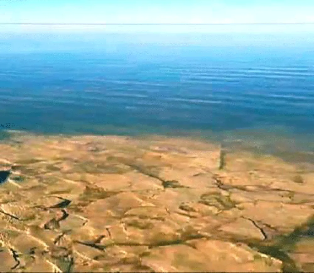
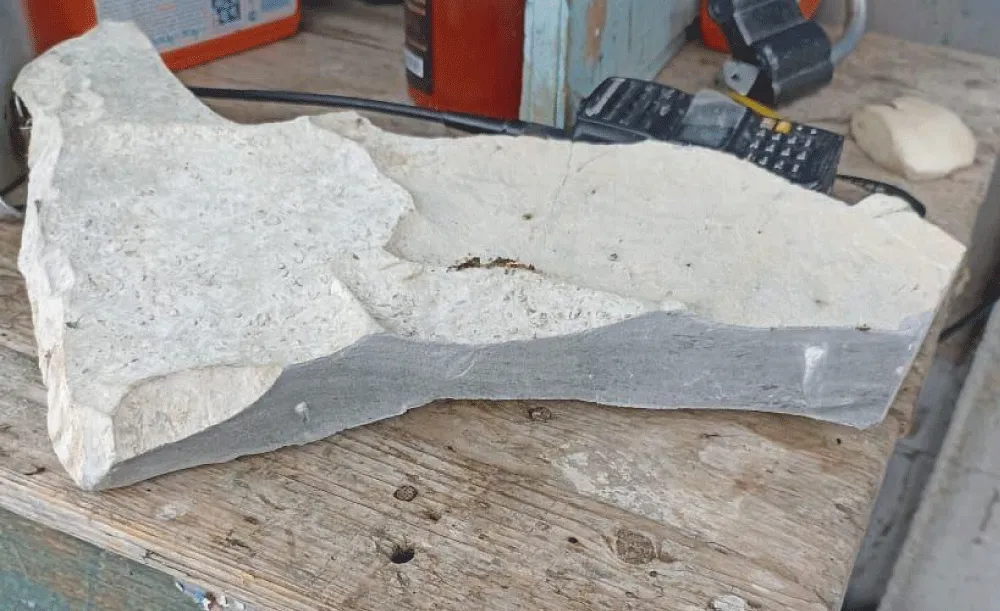
The discovered rock, which is not typical for the Northern Caspian, is a light‑colored, dense, plate‑like, flattened, rocky formation. The depth of the sea in the area of the discovered shoal at the time of its survey, under nearly calm weather conditions, was no more than 0.5–1.0 m.
The discovered rock, which is not typical for the Northern Caspian, is a light‑colored, dense, plate‑like, flattened, rocky rock. For further study, a sample of this rock was taken. On the surface of the sampled rock, there is a thin, uneven, loose film of light‑yellow carbonates (Figures. 4, 5). The sea depth in the area of the discovered shoal at the time of its survey, under virtually calm weather conditions, was no more than 0.5–1.0 m.
On a fresh cleavage surface, the rock is gray in color. It is not uniform in color, and dark gray streaks and rare white inclusions are clearly visible on the cleavage surface. The rock has a microgranular structure (the crystal size is less than 0.01 mm). The texture is massive and uniform. The hardness on the Mohs scale is 3.0–3.5. The specific gravity of this rock is 1.76 g/cm3. No organic remains were found in the rock. The genesis is chemogenic. The sample absorbs water very well. When wet, its weight increases by almost a third (28.8 %). Fragile. When a drop of 10% HCl is applied to the surface of the sample, it reacts vigorously, with bubbling and fizzing. This indicates that the rock has a sedimentary origin and belongs to carbonate rocks. After exposure to 10% HCl, a light spot forms on the surface of the rock.
A fragment was chipped off from the rock and dissolved in concentrated hydrochloric acid to obtain an insoluble precipitate. After the reaction, the insoluble precipitate was separated, washed, and dried. In its dry form, it is a white powder, the amount of which accounted for more than 50 % of the original rock. The powder also contains rare small quartz grains and clumps of clay. The powder is finely dispersed and tasteless. Most likely, it is gypsum, CaSO4 · 2H2O. This assumption can also be made based on the presence of small (up to 1–2 mm) white crystalline gypsum inclusions with very perfect cleavage, which are visible on the fractured surface of the sample. They are easily scratched with a fingernail and have no taste. Therefore, we can conclude that this sedimentary rock is gypsum marl, which contains calcite, gypsum, and less than 1 % clay and quartz sand. All parts of the rock form a uniform, homogeneous mixture. Gypsum marl contains gypsum both in dispersed form and in the form of inclusions. Unlike ordinary marl, where limestone and clay predominate, here gypsum acts as an important rock‑forming component.
Typically, marl is not strong but rather chalky and loose. However, with increasing depth, at the stage of early catagenesis or protogenesis, it becomes denser, the carbonates in it recrystallize, and the marl becomes strong. The sample under study is stone‑like and dense. It was brought to the surface as a result of salt‑dome tectogenesis processes, and its age is quite difficult to determine.
More detailed studies of the samples will be continued at a later time.
The Caspian Depression is located on the southeastern margin of the East European Platform. To the east, it is bounded by the folded structures of the Urals and the Mugodzhary Mountains. The South-Emba Fault separates the depression from the Turan Young Platform to the southeast. To the southwest, the boundary extends under the Donbas- Astrakhan thrust zone. Within the latter, the Upper Paleozoic folded strata of the Karpinsky Ridge are thrust over the Paleozoic deposits of the Caspian Depression for 15–80 km. The total thickness of the sedimentary cover in the central part of the depression is up to 20–25 km, and in the peripheral zones it is 7–9 km; it contains three complexes: the pre‑salt, salt, and post-salt.
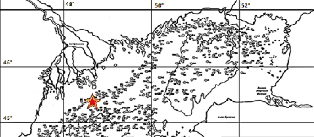
The salt Kurgan complex consists of rock salts with un выдержанными interlayers and lenses of terrigenous and carbonate rocks. The maximum thickness is 2–4 km. About 1,200 salt structures — diapirs, salt ridges, and salt pillows — have been formed within the Caspian Depression as a result of halogenesis processes (Figure 4) [4]. The suprasalt lithological complex is composed mainly of terrigenous sandy‑clay deposits with a subordinate presence of carbonate rocks in the Upper Jurassic and Upper Cretaceous, and it has been studied quite well. The upper (suprasalt) complex — sedimentary formations from the Upper Permian to Quaternary deposits — is composed of continental coarse‑clastic terrigenous rocks, marls, sandstones, and siltstones. Local structures (regional troughs and elevated zones) are widespread; they are controlled by salt tectonics. The density of the rocks ranges from 2.04 g/cm³ at the surface to 2.54 g/cm³ at depths of 4.5–5.0 km. The thickness ranges from 2–4 km (the rim of the depression) to 5–6 km (the central part).
Over the past 150 years, the northern region of the Caspian Sea has been subjected to various anthropogenic impacts, as well as global and regional climate changes, which inevitably affected the state of its ecosystem. However, the variability of underwater complexes under anthropogenic loads and external influences has not been sufficiently studied in quantitative terms. To identify the extent of the impact of anthropogenic factors on the Caspian ecosystem, study [5] presents the results of the relationship between changes in the level of the Caspian Sea and several climatic, hydrological, hydrochemical, and biological indicators of the natural environment. Quaternary and modern movements of an epeirogenic nature play a significant role — the gradual uplift and subsidence of large sections of the Earth’s crust, which stimulate abrasion or erosion by currents on rising sections, as well as accumulation in depressions or on uplifts [6]. As a result of the influence of these factors, numerous accumulative landforms — islands and banks — emerged against the backdrop of an overall level terrain. Sea ice can also exert direct mechanical, thermal, and physicochemical effects on the seabed and coastlines. Among these, the most dangerous is abrasion — the destructive mechanical impact of ice on the ground, which is associated with the dynamics of the ice cover, pressure ridging, and keel formation under the influence of hydrometeorological factors and the terrain of the coastal zone (Figure 5).
The processes of ice jamming are also significantly influenced by shallow water, the sinuosity of the coastline, and the complex bottom topography with a large number of underwater banks and spits. Under otherwise equal thermal conditions for ice formation, an important factor determining the intensity of the ice‑scouring process is the current sea level position.
An important and constant factor affecting the mechanical impact on the seabed of the Caspian Sea is the exceptional instability of its water level. According to archival data from observations, the water level of the Caspian Sea has also experienced fluctuations in the past. Annual increases in sea level of 20–30 cm were observed in 1865–1866 and 1895–1896. In the 20th century, two extreme phenomena were recorded in the long‑term trend of sea level, with dramatic consequences for the population of coastal countries: a prolonged drop in sea level between 1930 and 1977, followed by a prolonged rise between 1978 and 1996. By 1977, the average annual level of the Caspian Sea had broken the record for its shallowing over the entire period of instrumental observations, reaching −29 m above sea level.
Periodic rises and falls in sea level are currently regarded by the scientific community as a natural phenomenon. The Caspian Sea is located in a zone of constant influence from cold polar air masses, humid maritime air masses originating over the Atlantic, dry continental air masses from Kazakhstan, warm subtropical air masses coming from the Mediterranean and Black Seas, as well as those forming over the Caspian Sea itself.
From an academic perspective, the formation of the Caspian Sea occurred over the course of a long geological history, during which there was a repeated alternation of transgressive (advancement) and regressive (retreat) phases of its water level, varying in magnitude and duration. In the Tertiary period (about 70 million years ago), the Pontocaspian basin separated from the southern seas and the Tethys Ocean. At the end of the Pontian period (10 million years ago), the vast internal Sarmatian Sea, which encompassed the territories of the modern Black and Caspian Seas, broke up into separate parts, forming an autonomous, isolated basin of the Caspian Sea with the familiar contours we know today. During this period, the area of the sea was smaller than it is now, and in certain epochs of the Middle Pliocene, the Caspian Sea occupied only the basin that now corresponds to the South Caspian.
The materials of geomorphological studies show that the lowering of the Caspian Sea level in the twentieth century by 2.5 m was by no means sensational; there were shallows in its history and much more. However, the range of sea level fluctuations decreased over time. In the Pleistocene (the last 2.5 million – 500 thousand years), the amplitude of sea level fluctuations reached 150 m; in the Holocene (the last 10 thousand years), when civilizations had already appeared on the shores of the Caspian Sea, sea level fell and rose again within 12- 15 m (between minus 20 m and minus 35 m). In historical times (the last 2.5 thousand years), the range of sea level fluctuations did not exceed 10 m, and during instrumental observations (from 1830 to the present), it was about 4 m, but it was also more than 2.5 m. Another piece of evidence of the cyclical nature of the sea level is the fact that a continuation of the Derbent wall (about 500 meters) was discovered in the sea.
There are many hypotheses, assumptions, conjectures, and speculations on this matter. However, the process of the Caspian Sea’s formation was determined, on the one hand, by global geological phenomena, and, on the other hand, by regional characteristics. Therefore, it is believed that tectonic and mountain‑building processes had the predominant influence on the fluctuations in the Caspian Sea’s level during the early Neogene; in the Upper Pliocene, tectonic and climatic factors; and in the modern stage, climatic, tectonic, and anthropogenic factors.
A.S. Brusilovsky was the first (Figure 6) to map the location of salt domes in the water area of the Northern Caspian and to propose a hypothesis about the relationship between the state of the ice cover and the position of polynyas and the presence of salt domes in the water area of the Northern Caspian. He believes that in the shallow waters between the Volga and Ural rivers (it is here that polynyas are most frequently observed in the fast ice), the freshened Caspian waters, whose salinity is no more than 3–5 per mille, dissolve the tops of the salt domes. As a result, there is a significant local increase in water salinity, which, during the cold season, leads to a slowdown in ice formation processes and the formation of unfrozen areas [4].
The outcrop of bedrock we discovered in the North Caspian Sea and the analysis we carried out indirectly confirm the likelihood of such a relationship. Of course, our assumption about the erosion of gypsum-marl deposits (keproks) on the arches of salt domes in the North Caspian shallow waters needs to be verified by drilling from the ice or by geophysical methods (possibly quarter‑milligal gravity surveying, i.e., high‑precision gravimetric surveying with an isoline spacing of 0.25 mGal).
The presence of salt domes in the water area of the Northern Caspian Sea affects not only ice formation processes. They also manifest themselves in the hydrological and hydrobiological characteristics of the waters in these areas of the sea, which is of not only scientific but also practical interest. Changes in the underwater landscape and soil structure have led to the complete disappearance of algae and, as a result, to a change in the composition of hydrobionts. The nature of the interaction between drifting ice and rocky soil has also changed. If, in soft and loose soil, the underwater keels of drifting ridged ice form characteristic ploughing furrows, then upon interaction with hard rocky soil, it is crushed, which is clearly visible in Figure 4.
Unfortunately, these areas of the sea are difficult to access for expeditionary research, both from the sea and from the shore, so it is too early to conclude. Due to the development of space technology in our country, fundamentally new, promising methods for studying the hydrological regime of seas and oceans have been developed, which will undoubtedly help in further research into the processes of salt‑dome tectonics in the shallow northern part of the Caspian Sea.
In conclusion, it should be noted that research on this phenomenon is at an early stage and will undoubtedly continue. In the near future, fieldwork, exploratory drilling, and laboratory studies are expected. Given the current lack of direct geophysical data and well drilling results, we have tried to present our interpretations regarding the role of salt dome tectonics with caution and have not gone beyond what is supported solely by the available evidence.
Information about authors
Bukharitsin Petr Ivanovich, Doctor of Geography, Professor, Expert group of the Institute of Water Problems of the Russian Academy of Sciences, expert.
Ilya Vladimirovich Golovachev, Candidate of Geographical Sciences, Associate Professor, Astrakhan State University named after V.N. Tatishchev, [email protected]
- Katunin DN, Khripunov IA. Dynamics of the Northern Caspian Sea soils. Izvestiya Vsesoyuznogo Geograficheskogo Obshchestva. 1971;103(5):469-475. (In Russian).
- Glumov IF, Malovitsky YaP, Novikov AA, Senin BV. Regional'naya geologiya i neftegazonosnost' Kaspijskogo morya [Regional geology and oil and gas potential of the Caspian Sea]. Moscow: Nedra-Businesscenter; 2004. 342 p. (In Russian).
- Lebedev LI, Aleksina IA, Kulakova LS, et al. Kaspijskoe more: Geologiya i neftegazonosnost' [The Caspian Sea: Geology and oil and gas potential]. Moscow: Nauka; 1987. 295 p. (In Russian).
- Pisheva KE. Gidrogeohimiya (formirovanie himicheskogo sostava podzemnyh vod) [Hydrogeochemistry: Formation of the chemical composition of groundwater]. Brusilovsky SA, editor. Moscow: Moscow University Publishing House; 1978. 328 p. (In Russian).
- Mitina NN, Malashenkov BM, Telitchenko LA. Podvodnye landshafty Severnogo Kaspiya: struktura, gidroekologiya, ohrana [Underwater landscapes of the Northern Caspian Sea: Structure, hydroecology, and protection]. Moscow: IPR RAS; 2016. 215 p. (In Russian).
- Leontiev OK, Maev EG, Rychagov GI. Geomorfologiya beregov i dna Kaspijskogo morya [Geomorphology of the coasts and the bottom of the Caspian Sea]. Moscow: Moscow State University Publishing House; 1977. 208 p. (In Russian).



 Save to Mendeley
Article Alerts
Subscribe to our articles alerts and stay tuned.
 This work is licensed under a Creative Commons Attribution 4.0 International License.